Yes, you can drive on Forest Service roads. The U.S. Forest Service allows everyone to drive their vehicle on all Forest Service roads as long as the roads are not closed off with a locked gate. However, it also depends on what kind of vehicle you are driving.

Can You Drive on Forest Service Roads?
All Forest Service roads are open to the public. The only roads that are not open are those that are closed off with a locked gate, or barricaded off with a sign saying, “Road Closed”. Otherwise, as long as the road is open, it’s open to the public.
However, it also depends on what kind of vehicle you are driving or riding.
About Half of All Forest Service Roads Are Off-Limits to Non-Street Legal Vehicles
About half of all Forest Service Roads are classified as being off-limits to non-street legal vehicles. That is, only street legal vehicles can drive them. These roads are typically paved, but many others are dirt or gravel. In all cases, these roads are the “main” Forest Service roads and are intended strictly for the general populace.
By contrast, most of the smaller Forest Service roads that branch off the main roads are open to both street-legal and non-street vehicles.
Street Legal Vehicles Versus Non-Street Legal
The U.S. Forest Service classifies every vehicle in terms of “street legal” and “non-street legal”. The terms, “off highway vehicle”, “off road vehicle”, “OHV”, “UTV”, or “ATV”, does not mean anything to them.
A street legal vehicle is simply a vehicle that can legally drive on public roads within that state. This also means it has to be legally registered in that state, and meets all other legal requirements. A Polaris RZR or Yamaha Raptor can still be considered a street-legal vehicle as long as it meets all the state requirements for street use.
By contrast, a non-street legal vehicle is any vehicle that does not meet the legal requirements to be driven or ridden in that state.
How to Tell Which Roads Are Which
The only way to know which roads are open to all vehicles, and which roads are off-limits to non-street legal, is to look at a “Motor Vehicle Use Map”.
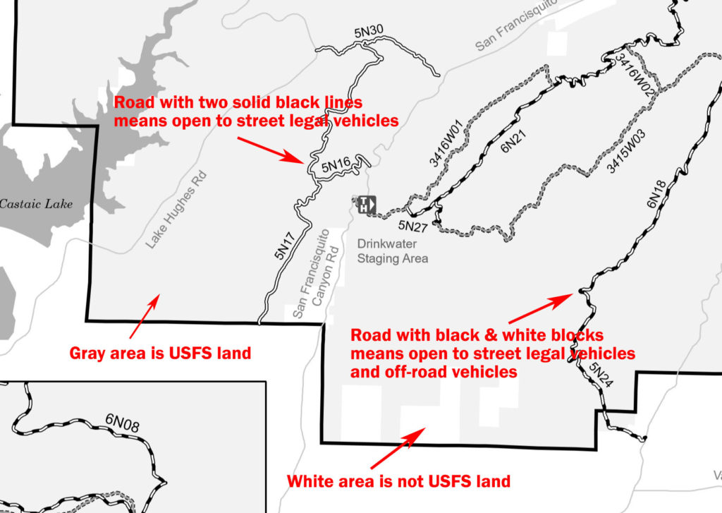
Each national forest and grassland publishes its own Motor Vehicle Use Map. This map illustrates which roads are which…

In the map above…
- Forest Roads with two solid black lines are limited to just street legal vehicles only.
- Forest Roads with black & white blocks are open to all vehicles.
Where to Get Motor Vehicle Use Maps
- Each national forest and grassland will have printed copies of these maps at a visitor center or ranger station.
- Most forests and grasslands offer downloadable PDF copies of their maps. To find them, go to the U.S. Forest Service website (click here), and then drill down to a specific forest or grassland.
- FreeRoam is a boondocking app that actually has most of the Motor Vehicle Use Maps built-in. Read more about Free Roam here, “Using FreeRoam to Find New Boondocking Sites“.


In the state of Tennessee I have my side by side tagged and street legal is a class 1 tag good on forestry road in Cherokee national park in Tennessee
Since the 1940’s the land has been in family the Cherokee Forest next to my property telling me cannot drive on road to get to my property.